Friday, February 12, 2016

Day 26 - Highway 285 and Driving Thru West Texas

Woke up cold but too early to take the camper down. This campground has all-quiet hours. Went to the warm laundry room and downloaded photos from our day in the Sabino Canyon. Yes, I am very far behind on the photos. Did morning ablutions when the rest of the camp woke up. Put the camper down (actually 3 times since I kept forgetting things in there that I needed), and hit the road. I am taking this opportunity to let you know that Carlsbad is only about 70 miles south of Roswell, New Mexico, so there are a lot of alien mementos and signs in town. Also, since the caves are formed by hydrogen sulphite mixing with limestone, it is immediately apparent when you drive into town that the soil is loaded with hydrogen sulphite - the whole town smells like sulfur. But I did like it there. I can see how it might be a great place for a summer vacation in the Southwest because it is about 20 degrees cooler there than it is at 1,000 feet elevation.


Well, I almost hit the road. I stopped to gas up in Carlsbad, and then stopped at the No Whiner Diner for breakfast. The only whiner in that restaurant was the owner, who is a world class whiner. And they overcharged me for my meal. Skip it, and let him whine in peace.

Took Highway 285 down to I-10 in Fort Stockton, Texas. Highway 285 in New Mexico is the WORST stretch of highway that I have ever driven on in my life! Just awful - and no rest stops either. I had to pull over after about 3 hours of driving to take one of my famous 15 minute naps, and had to just pull over on a wide and gravely right-of-way by the side of the road. Highway 285 improved somewhat in Texas. Picked up I-10 in Fort Stockton and headed east to San Antonio. The towns in West Texas are about 70 or 80 miles apart so you have to make sure you gas up whenever you have a chance.

So ecstatically happy to make it to Ozona, Texas about 6 pm with about one-sixth of a tank of gas. I-10 in West Texas is very straight and mostly flat since those Texans just blast their way thru any foot hills that stand in the way of an interstate construction project. There were a few rolling hills to drive over, but not much scenery. It can get kind of boring. Then, the speed limit is 80 miles per hour, which after a few hours seems pretty tempting - even with a camper. I stopped for gas one other time when my tank got down to half full, just in case, and to stretch my legs. Made it to my campground in San Antonio about 11 pm. I was so tired, my eyes weren't focusing, so I just slept in the car with a sleeping bag thrown over me. That made for a really, really, really long day sitting in the driver's seat in my car. Should have thought that thru more carefully, but too tired to think too.

Here is the map of my cumulative travels. Have put 4,700 miles on the Subaru so far.

Wednesday, February 10, 2016

Carlsbad Cavern

Today (Monday) was the day to go exploring in Carlsbad Caverns. For anyone keeping track, visiting as many National Parks as I can is one of the items on my personal bucket list. So far, I have been able to visit 3 National Parks and 1 National Monument - which is something that should be a National Park, but Congress can't agree on whether or not to take potty breaks.

I had breakfast in town and spent some time downloading photos from my camera and enjoying a warm place to sit for a while. And then when I finally got on the road to the Caverns, I stopped to take some photos at an "exhibit" (National Park Service term - not mine) along the road into the Park. The road up to the National Park visitor center is on the side of a narrow canyon cut by water many millenia ago thru the Gaudalupe Mountain range. The narrowness of the canyon increases the impressiveness of the mountains that seem like they are right on top of you. It made me feel like a puny person in a puny car in relation to their enormous size. The "exhibit" was a deep rock overhang that could provide shelter and shows signs of being used by many native human cultures over many thousands of years. There are signs of fire and other indications of human habitation in the shelter. There is also a clear, deep water pool nearby - and the entire Southwest has been having a 5-year drought!

In addition to that feature, there are also some mountain ranges on the drive up that look like black sand dunes.

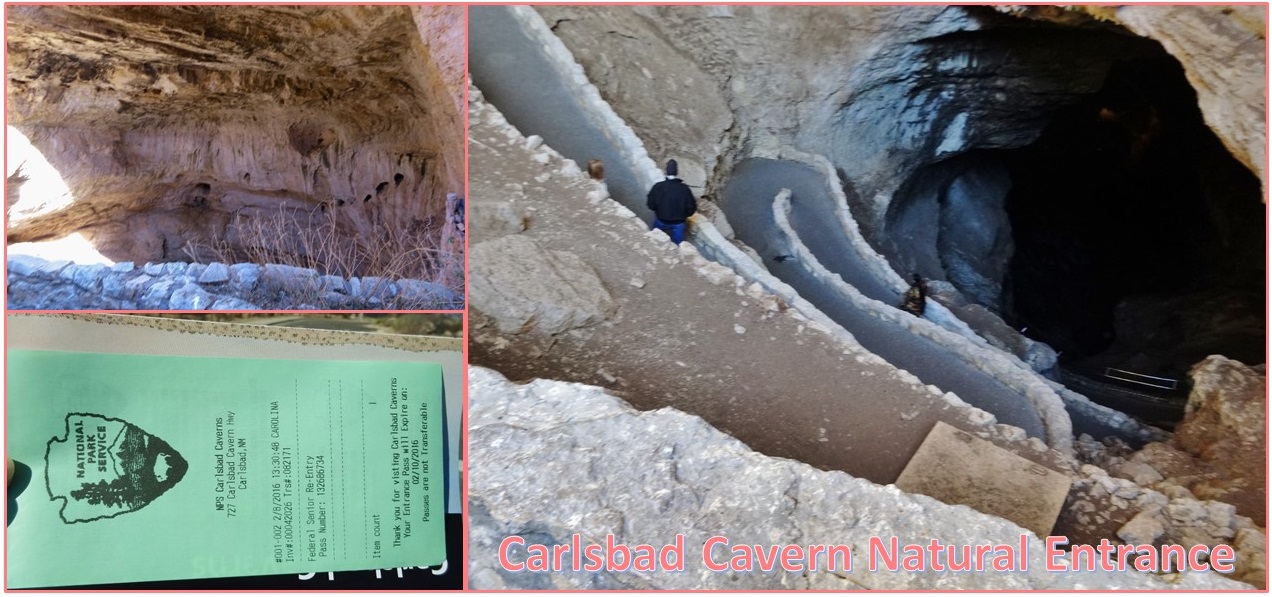
My senior pass got me free admission to the Caverns, after I answered a bunch of questions about which caves I may have visited in the last 8 years and whether I was wearing any of my current clothing when I went in the cave. I did go to Natural Bridge Cave in San Antonio and Wind Cave in the Black Hills just exactly 8 years ago, but that was fine. They also prohibited me from taking my walking stick into the cave with me. This will become important later. Did I mention that the elevator to ride back up was broken? Yes, it was.

Since I arrived at 1:30 pm, that meant that I would have 3 hours in which to walk 1 1/2 miles down, view the Big Room, and then walk 1 1/2 miles back up again. The ranger warned me that I would not be able to see all of the Big Room and that a ranger at the bottom would close off the furthest reaches of the Big Room as he judged that anyone entering them at that time would not be able to walk back up and out of the cave by 4:30 pm. This photo shows how steep the switchback trail is in the cavern.

I took a restroom break (3 hours - hello) and rented an audio guide of the tour. I think I missed a few points of interest along the way because I missed the numbered signs, but overall the guide was really interesting. I found that I could listen AND walk, although the rangers did not think that possible. :)

I got almost half-way down into the cave before I started seeing drip formations; they called them speliotherms. Since this was not my first cave exploration, I was judicious about which photos I took, but I still took a lot. There was only one pool in the part of the cave that I saw because of the drought. I did see some formations (speliotherms) called "lion's tail" that I had never seen before. All the formations are brown - or the colors of limestone.

Important speliotherms on the trip down and what I saw in the Big Room: Whale's Mouth, Witches Finger, Iceberg Rock, Green Lake Room (no lake now), King's Palace, Queen's Chamber, Papoose Room, the Boneyard, Hall of the Giants with Giant Dome and Twin Dome, and Temple of the Sun God (thought this one was ugly so didn't take a photo). The Hall of the Giants is in the Big Room. The ranger in the Big Room stopped me from going any further because I had to walk back up 1 1/2 miles of steeply slopped trails (remember the broken elevator?). The hike down took 4 minutes and really blew out my right knee. I spent about 15 minutes in the Big Room and the hike back up took 75 minutes - with frequent rest stops at benches - rock benches or wooden benches. I made it!!!


The rangers would not allow us to bring in water, and the air in the cave is warm and damp, occasionally dripping. When I got out, I was parched and sweating. And then I discovered that they had "winterized" their water fountains, so I couldn't even get a sip from the fountains. I bought some post cards at the gift shop and asked about a book identifying some of the formations. The man in the book store just gave me a video. He said his nonprofit had lost their contract to run the store. Lucky me. When I got back to the car I chugged down the rest of my water and a whole bottle of ginger beer.

Had supper at Arby's, did laundry, wrote in my journal and on some post cards. Still no heat tonight. But I had perfected the tent within a camper concept.

Day 24 - Adios Tucson; Buenos Noches Carlsbad

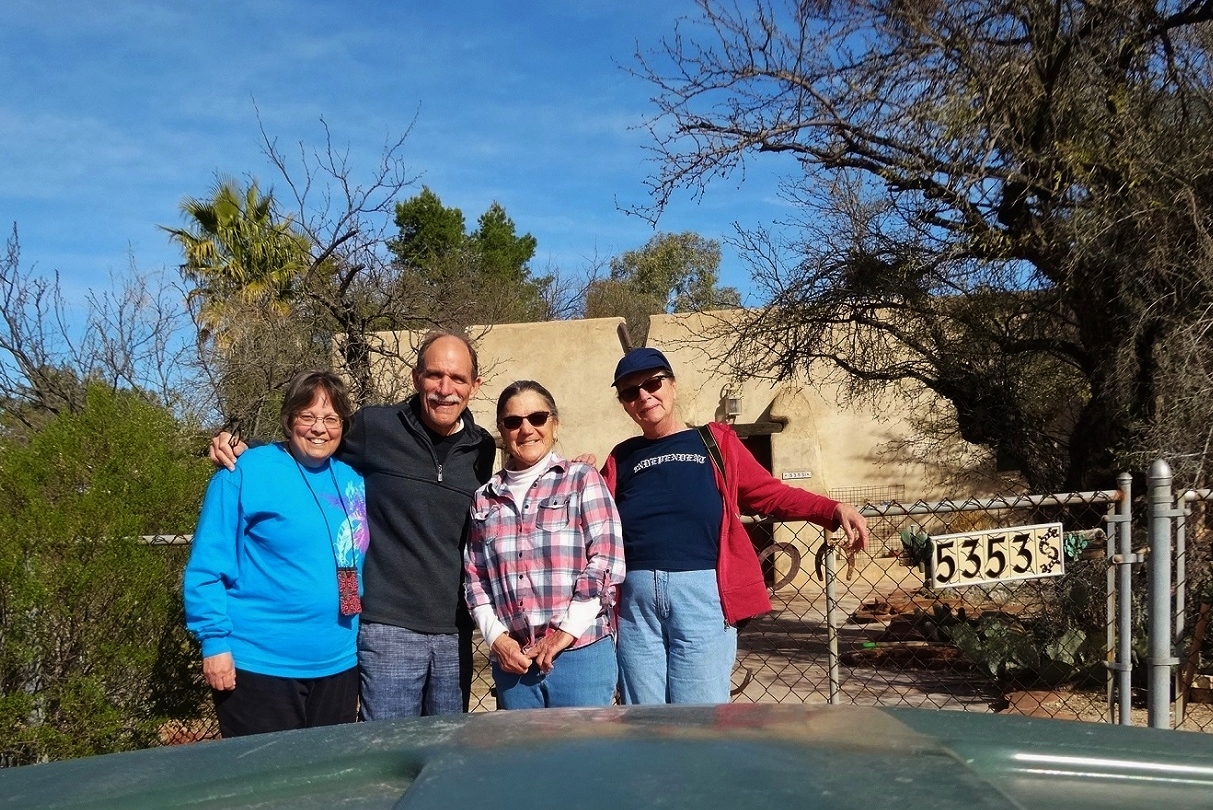
Time to say good-bye - to Tucson, to the Saguaros, to Colleen and Dan. This is the first place where saying good-bye has been really hard. Colleen and Dan helped up pack up the car and get the camper hooked up. We took one last photo of us all, then hit the road.

Carol & I drove straight thru to Las Cruces, except for gas at Lordsburg. I remember laughing a lot, but now can't remember why. I think we probably did have a couple more stops and found hilarity with the local populations. We arrived in Las Cruces at 3:15 pm. Carol's friend Gail arrived at 5:15 pm. I spent the time in a nearby KFC, writing in my journal. We loaded Carol's stuff in Gail's car and said good-bye. Thus ends Pat & Carol's Excellent Adventure. It has been great having a travel companion and sidekick for this 3 weeks.

I headed for El Paso. I was worried about driving thru El Paso because I had received so many warnings about it. That traffic is horrible and the mountains one has to go over in town are steep and have a stop light at the bottom of a steep descent. Luckily for me, I was traveling on Sunday. No traffic at all. I took the 375 Loop which goes thru the Franklin Mountains. Most of the trip was spent in 4th and 5th gear; twice I had to go down to 3rd gear on an ascent to keep the RPMs above 2,000 so the car would be able to bring the camper with it. Piece of cake! I filled up my gas tank in El Paso after clearing the mountain pass (not knowing when I would see a gas station again) and hit 180/62 - at night - in the dark - to Carlsbad, New Mexico.


The trip was uneventful. What is it with the white pick-up trucks out here? They are every where. Most of the trip was a gradual ascent up into the Guadalupe Mountains. I had also received dire warnings about high winds at the base of the Guadalupe Mountains. The winds were less than 15 mph. At one point when I had passed two signs warning of high winds, I stopped the car to see how high the winds were. We had higher winds in Oklahoma. This didn't even blow my hair to the other side of my part.

Near Rattlesnake Springs picnic area, I hit something in the middle of the road. It may have been a car fender. Not mine - my fender is still fine.

When I got to my campground at 8:45 pm and put up the camper all by myself, I discovered there was damage to the camper. The side of the utility drawer cabinet was pulled off. And now the electricity to the whole camper does not work -- not even after trying the sink switch! Temperatures dropped to 25 degrees in the high desert overnight. I improvised a mini-tent inside the trailer with 3 sleeping bags and my round pillow. Mostly stayed warm. Not sure how much oxygen I had that night.

Car has clocked 4,150 miles since leaving my house in Saint Paul on January 15th. And because I know you are enjoying the maps, here is the Day 24 map.

Tuesday, February 9, 2016

Driving Miss Pat, Miss Carol, and Miss Colleen

Dan joined us on our Saturday adventure - and he drove - mostly because he had planned out the day. Our only requirement was that Carol and I wanted to take them out to dinner that evening. Dan did well!

First up was a tour of Dan's students' murals. A woman in Tucson, whose 2-year-old son Ben died several years ago, started a foundation called Ben's Bells. She said that nothing people said to her made her feel any better, but simple acts of kindness did. She started giving bells to people who had done her a kindness and encouraged others to do the same. That led to registering the bells on a website with the recipient names. She got a grant to do some ceramic tile art on benches on the University campus. People painted the name of a person or organization who had demonstrated kindness. They fired the ceramic tiles and attached them to 3 or 4 benches in the college quad. This is where Dan came in. He runs a program for K-12 students with disabilities. His students helped with painting and firing the ceramic squares.

Dan's students' role in working in ceramics grew as Ben's Bells grew. Second to large murals near the University in concert with a famous outdoor muralist from Philadelphia. Then a large 4-sided mural in a plaza downtown. Now they have two workshops creating all kinds of ceramic kindness reward items - bracelets, coins, etc.

We did the whole tour of all Dan's students' murals. You can see from the photo how the concepts have matured as their work in public art has grown larger and larger.


Next up was a drive up to "A" Mountain. "A" Mountain has a giant A painted on rocks piled to to make the letter and painted white. From that spot, you can see all of Tucson. The view is spectacular! Apparently rival schools try to paint the "A" in their school colors, which leads to Tucson United school students having to keep watch a few nights before each game to ensure the "A" stays white. Sounds like that would be great fun for a high school student.

Third spot on Dan's tour was the mission church at San Xavier (which Tucsonians pronounce "sanaveer" or San Javier). It is a gorgeous old adobe church built by Spanish priests from Mexico sent to Tucson on an evangelical mission. You can see in the photo on the right that they are in the process of restoring the exterior of the church. One tower is finished and one tower is not. The mission church started in 1692, and the current church was constructed over 14 years between 1783 and 1797, making it the oldest European structure in Arizona.


All the statues inside the church are also adobe, as well as some outside the church (there are a lot of statues). Dan's parents celebrated a reconsecration of their marriage vows there for their 50th anniversary.
We spent a lot of time there sitting in a pew and taking in all the artwork. The word is overused - but the sheer amount of naive art in that space was amazing. My interior photos all turned out fuzzy; this is the best I could do.

We walked the courtyard and the gift shop (where I bought some post cards). We lost Carol so went looking for her on the hill there there is a grotto and some benches for quiet reflection. We found her coming out
of another gift shop on the site. Dan bought us all one humungous Indian fry bread which we shared. A group of Native Americans were frying them up and selling them in the parking lot for Saturday evening mass attendees. It was light, airy, and delicious. San Xavier is located on what is otherwise a reservation. On our way out, I saw my second road runner - and yes, he was sauntering on the road.

We headed over to El Charro in the Presidio for dinner - on me and Carol to thank Colleen and Dan for cooking for us for the past 4 1/2 days and for everything they did to open their home to us and make us feel like it was our home. El Charro doesn't take reservations and we had an hour wait for a table, so we went shopping at a small art alley just around the corner also in the Presidio called Old Town Artisans. The shops were in a rabbit warren of twists and turns with lovely things around every corner. I bought 4 green and red pepper Christmas ornaments for the grandkids. We did a lot of window shopping. By the time we walked slowly back to El Charro, our table was ready.

I had a chicken mole enchilada as I was told that their mole is fantastic. And "they" did not lie. Dan had a carne seca burrito. He said that is dried beef - and El Charro dries their own beef on site. We all had great meals, and shared a pitcher of Margarita (made with real limes - nummm).

It was such a fun day and fun evening! We arrived home at 8 pm, but it felt like midnight - we had such action-packed fun in Tucson. I worked on the trip blog until bed. Took a photo in the morning of all four of us sitting at the table working on our separate computers - a common site this past week.

Saturday, February 6, 2016

Tombstone - the Town Too Tough to Die

On Friday, Colleen took the day off work and went with Carol and me to Tombstone - which yes, is in Arizona.

Colleen drove, and took us on the long route thru Sonoita and alongside the Santa Rita Mountains. We saw a different side of Tucson - rolling hills of cattle raising grasslands. And lots and lots of RV campgrounds. It was a beautiful drive.

The first stop in Tombstone was at Boot Hill Cemetery. We stopped at the Visitor Center to get a map and a listing of all the people buried in the cemetery - along with their cause of death - or Epitaphs. Most of them died from violence in the early 1880s; many of them are unknown. We walked along the rows in the cemetery while I read out what they died from. Colleen said later that she was glad that we started there; it gave a different perspective to the experience.

We drove into town, parked, and walked down Allen Street, which looks just like it did in the 1890s. The old town burned twice, so it doesn't look
like what it did in 1881 when the shoot-out took place. But it is old, and is on the National Historic Register as an Historic Place. First stop was Big-Nose Kate's Saloon for a drink and lunch. I had a cactus cooler, which is wine and cactus juice. Colleen had a Bloody Mary. Can't remember what Carol had. For lunch I had a Texas brisket beef sandwich that I could barely get in my mouth it was so big. We took lots of photos in the saloon. Everyone who worked there, and some who didn't were all duded up in old-time cowboy gear or saloon hall floozy gear. The guy with the concertina was the entertainer, serenading us with old tunes everyone knew. It was picturesque.

I had a shot of whiskey before we left, after noticing that the whiskeys took up more than half their back bar.

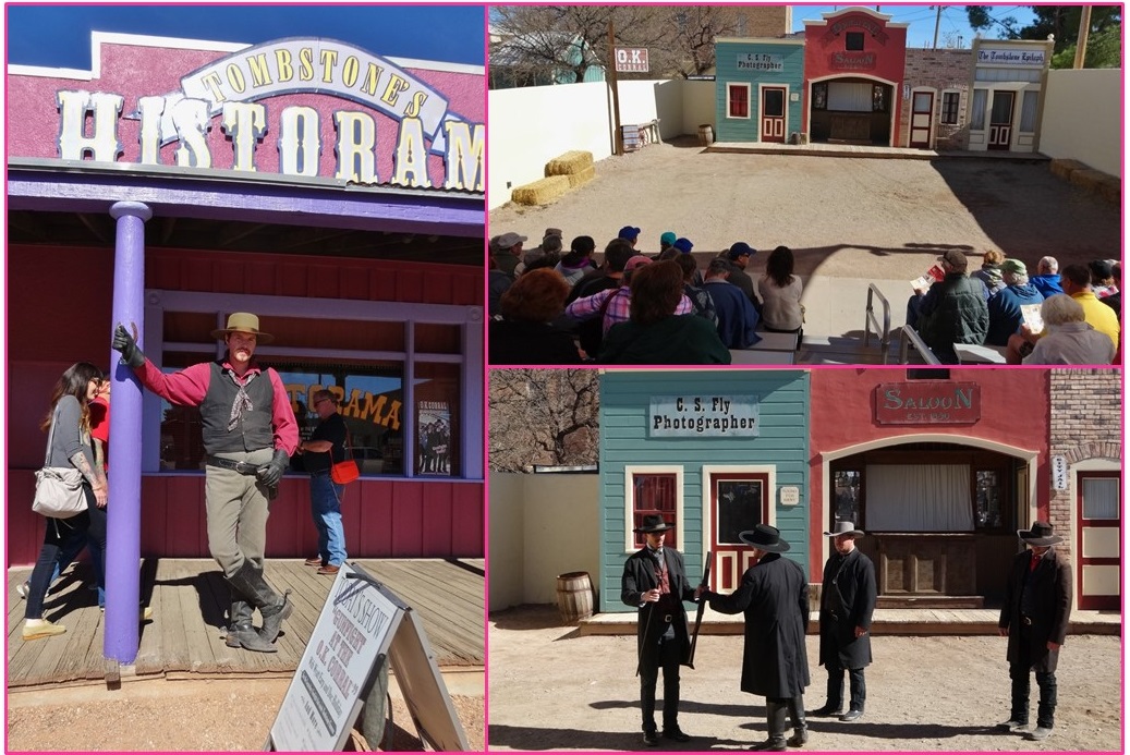
Since the shoot-out at the O.K. Corral took place at 2 pm, and it was about 10 minutes to 2 pm, we headed there, bought our tickets, and found seats in the bleachers. At noon, 2 pm, and 4 pm every day, seven actors re-create the shoot-out at the O.K. Corral in what they call a "Histodrama." 30 shots in 30 seconds. It is done like an old-fashioned morality play where the audience is encouraged to cheer for the good guys and boo and hiss for the bad guys. We all did our part well. It was great fun. Doc Holliday played the Deux ex Machina and told us what happened to the 4 people who survived. Most of them died of gunshots later. Only Wyatt Earp survived to a ripe old age - mostly because he moved out of Tombstone.

I bought a photo of Wyatt Earp and some postcards in the gift shop. On the Lindgren side, we have some relatives who married into the Earp family. Then Colleen and I went to the Visitor Center - nothing much there - bought some more post cards. Carol went to the Courthouse searching for the jail.

Colleen and I rode the stagecoach which took us down Allen Street and back up Toughnut Street (named for the Toughnut gold mine). The narrator on the stagecoach (I think it was a recording) also told us the Big-Nose Kate was named for her propensity to stick her nose into other people's business. She was also Doc Holliday's girlfriend. The guide pointed out that the real shoot-out did NOT happen at the O.K. Corral, but rather on Fremont Street right behind the Corral. He also told us that the fight had started earlier in the day at the Oriental Saloon - still a bar/restaurant now called the Crystal Palace. But, he explained, many of the buildngs there today were rebuilt following two fires in the 1880s and early 1890s that burned down most of the current old town - 66 buildings were burned in one fire. The town isn't really a re-creation because it was rebuilt at the turn of the last century, mostly with one-story buildings while the older town had mostly two-story buildings.

After alighting from the stagecoach (not an easy feat), we headed over to the Courthouse to find Carol. The Courthouse was actually the federal building, so it also housed the U.S. Post Office, federal prosecutor, and several other federal agencies - probably the land office for one. We toured all the rooms, checked out the gallows and took some photos there. Carol spent some time in the jail in the yard. I warned her not to rustle my cattle.

I really wanted some old-time photos, so we headed to a photo shop. Carol & I dressed as saloon floozies, and Colleen dressed as Warren Earp. The photo turned out great - you will just have to take my word for it until I am someplace where I can scan it. We all had guns and looked mean - we just don't cotton to no varmints.

Next we stopped at the Crystal Place where the events leading up to the shoot-out took place. Colleen and I took a photo in front of their famous back bar. This place was worth seeing. We stopped at a couple of other stores, but found only some Sarsparillas. Made one final stop at the Bird Cage Theater. Really hokey; the proprietor seemed like a real snake oil salesman.

When we got home, Dan was making "build your own" personal size pizzas from scratch. I had pesto and red sauce, olives, tomatoes, red peppers, roasted garlic and fresh mozzarella cheese on mine. It was fabulous!!!! Thanks Dan. After dinner, we played with our computers for a while. Dan announced that he was going with us the following day and he had a plan! Surprise Saturday. Love it!

Sabino Canyon and 4th Avenue in Tucson

Thursday, we decided to visit Sabino Canyon in the Catalina Mountain range just north and east of the City of Tucson. It is actually not that far from Colleen and Dan's house. Happily we discovered that it is managed by the National Forest Service who honors National Park senior passes, so entrance and parking were free for Carol and me since we both have senior passes. First stop was the Visitor Center to pick up a map. The ranger there suggested taking the 3.8 mile tram ride up the mountain to its terminus. There were at least 7 and maybe 9 tram stops along the way where one could get off the tram and then get back on later if you held up your ticket stub at the stop for the driver. Each tram stop is the starting point for a trail that wends it way up a mountain. In summer, the tram stops are popular for locals to get off and go swimming.

Which brings me to the most important feature of Sabino Canyon. It is the place where snow melt from the mountains, and more specifically Mount Lemmon, run down toward Tucson providing most of its water supply. It had just rained heavily (like somewhere around 4 inches) in Tucson about two or three weeks before we arrived. And, more importantly, Mount Lemmon had received a lot of snow. Snow is extremely important because it doesn't run off all at once. The snow melts gradually and is the gift that keeps on giving for a desert community like Tucson. The snow melt has carved its way down thru the mountains and into the Canyon gorges creating some stunning scenery.

Since it had recently rained (and snowed) heavily, the water in the stream was overflowing the WPA-built stone bridges that cross the creek many times on the way to the top. The bus had to travel four times over fast-running water that over-topped the narrow bridges. The trip climbs in elevation from 2,800 feet at the Visitor Center to 3,300 feet at the turn-around point. It was great for us Minnesota girls to smell water again - especially in the crisp mountain air. The WPA bridges were beautiful. The whole trip was one big photo opportunity. We were able to get off at the top to photo the canyon floor below. The driver said many movies have been filmed in that canyon, including "How the West Was Won" and "Three Amigos." The stop at the end includes a 5 minute break so the tourists can snap photos. And of course we did. There is also a stepped trail that leads further up that mountain peak. We were both tired of hiking and decided to take it on this trip. We road the tram back, picking up returning passengers at almost every stop, and taking even more photos. One day I will get them all downloaded.

Forgot to mention that I saw my first road runner (classically running on the road) while waiting for the tram at the Visitor Center.

We left Sabino Canyon and headed for the college section of Tucson - 4th Street and 4th Avenue. We parked on 4th Street at a meter and walked for a few blocks. Since it was past lunch time, we were searching out a good lunch place that would provide Carol with some vegetarian options. We settled on Delectables, which had a great street vibe. It did not disappoint. I had the chicken and spinach enchilada which was served with mole sauce, black beans, and sliced avocadas. It was delectable. The restaurant had a round glass case showcasing their desserts. Not being able to resist, I had a peanut butter mousse with chocolate ganache tart. Carol had a raspberry chocolate concoction. They were so big, we could only eat half, and took the other halves home. Later we found out that Delectables was a suggested stop in her AAA tour guide.

We walked along 4th Avenue for several blocks after lunch window shopping, and occasionally really shopping. Carol found a hat she had been searching for ever since we left San Diego. She also located the co-op grocery store where she used to work when she lived in Tucson in the early 1970s. We walked and window shopped (they had a lot of retro 1950s clothing in the windows of several shops) our way slowly back to the car.

Back at the hacienda, Dan and Colleen had made another lovely meal. After dinner, we watched the Democratic Presidential debate between Hillary Clinton and Bernie Sanders in New Hampshire. I am feeling the Hillary.

Saguaro National Park

Wednesday, we took in Saguaro National Park. We actually got kind of a late start because we were busy downloading photos from our cameras, and I was busy adding photos to previous blog posts - like the day at the beaches in San Diego - to the blog. I am having so much fun that I am getting behind on my blog posts, as you will note since I am adding Wednesday on Saturday.

We finally got going to Saguaro about after 2 pm. I stamped my National Park Passport. When we checked in at the Visitor Center, there was a ranger talk on how hard it is for the Saguaro to propagate. We decided to attend the lecture, and were glad we did. Each Saguaro puts out about 40 million seeds in its lifetime, but is lucky if one of two of them germinate and turn into an adult cactus. After the cactus blooms and the seeds the birds or people don't eat fall to earth, it has only a 2 month window to receive 2" of a gentle rain in order to germinate. Since this is a desert climate, that doesn't always happen although the Saguaro does time its bloom for just the right season to make some rain a probability. Then once it has germinated, the new Saguaro plant is extremely tiny and can be killed by an animal or human accidentally stepping on it because it is hard to see. It takes about 10 years for a new one to grow knee high. When you look out over this valley at the hundreds of thousands of Saguaro standing sentry there, it seems impossible that this giant plant could have been that successful against those odds. An adult Saguaro will live for anywhere to 150 to 300 years, depending on bird or human depredation and resistance to natural diseases. The ranger said that no one knows why some of them have only one or two arms and some have six or more. She also said that it is against the law in Arizona to harm or kill a Saguaro.

Since we had walked thru the cactus garden attached to the Visitor Center the night before, we headed right out on the Bajada Loop Drive. First stop was the Desert Discovery Trail, a one-half mile hike. We walked that and took photos. We discovered a new plant we had never seen before. Dan identified it as a Buckhorn cholla. It was bearing a profusion of still-green fruit with some just turning to yellow in February! We also saw a lot of baby Saguaro now that we knew what to look for.

(br>
Next stop was Valley View overlook which was designed as a photo op for the cacti since the dirt road was too narrow and too busy to pull over to take photos. We did take advantage of the view. Last stop was Sand Hill picnic area. A short hike (that the Park had helpfully stepped with rocks) up the mountain to some petroglyphs could be accessed from the back side of the picnic area. Of course, we took the hike. At the first sign, it was hard to see them at first. Look up; way up. We took the steps all the way up to the top of that mountain peak which is where most of the petroglyphs are located. They are in remarkably good shape. I think perhaps because they are mostly on the side of what are granite surfaces.


It was after 5 pm when we finished the Bajada Loop Drive and exited the park. But we did not really "loop" and were not back at the Visitor Center. It took us a while to figure out how to get back to where we started. The drive exits onto Sandario Road and one has to turn left onto Mile Wide Road (an ironic name) to get back to the Visitor Center. Taking the drive from the Desert Museum to Saguaro National Park, we noted how close one gets to those giant cacti on the road itself, so Carol took a movie of it while I drove thru it. I hope the movie captures the magic of the scene as we experienced it.I forgot to make a turn and we got lost for a little while, and so ended up getting back to home base a little late. We had soup for dinner, which was just perfect after our day in the mountains (it can be a little chilly up there especially as the sun sinks slowly in the West).

Called Dejah to send wishes to her on her special day. She is still stuck on going to a Baptist college in Waco, Texas. I can't picture that being a good choice long-term.